The County links to the documents no longer work due to County Roads censoring these Master Plans from the County website in early 2024.
However, the pedestrian-expressway maps and pedestrian and bicycle portions of documents have been saved to this website, with links provided below.
Update: I spoke to the BOS twice, and after four weeks of giving four different stories to BOS Aides on why they won't restore these County Master Plans, County Roads restored them
to the County website on 05/21/2024. The sidewalk-expressway maps were also restored.
The links may be different, so start with
this County link then scroll to near bottom.
The 2003 County Expressway Plan is a master plan of the County and is formally named Comprehensive County Expressway Planning Study Implementation Plan, County of Santa Clara. It is simply called the 2003 County Expressway Plan or Expressway Plan or Expressway Master Plan by most people and County supervisors. It was approved by the County Board of Supervisors on August 19, 2003 after a two-year public hearing process. The 2003 County Expressway Plan is cited by VTP 2030 [Valley Transportation Plan 2030, page 92], the main transportation master plan for the County, thus making it an official Master Plan because VTP 2030, in turn, is recognized by MTC as the Master Plan. [MTC, the Metropolitan Transportation Commission, allocates transportation funding in the San Francisco Bay Area]. With regard to pedestrians along expressways, it has these two major changes to County expressway policies of 1991:
The Santa Clara County Board of Supervisors voted to update the Expressway Plan, on March 3, 2009, to include sidewalks along expressways, usually on both sides of the road, with exceptions if a nearby route is available. Maps were generated and MTS verified the exceptions as being valid. Previously, a typical detour was one mile if the expressway was prohibited (to pedestrians, transit patrons and bicyclists) due to the hierarchical street patterns that force using arterial roads, and because these arterial roads -- which include expressways --- are spaced typically every half a mile.
To see high resolution maps, one for each expressway, scroll down to "2003 pedestrian-expressway maps" and/or "2008 pedestrian-expressway maps" and click the link for the specific expressway.
This map is page 90 of the 2003 County Expressway Plan (main section).
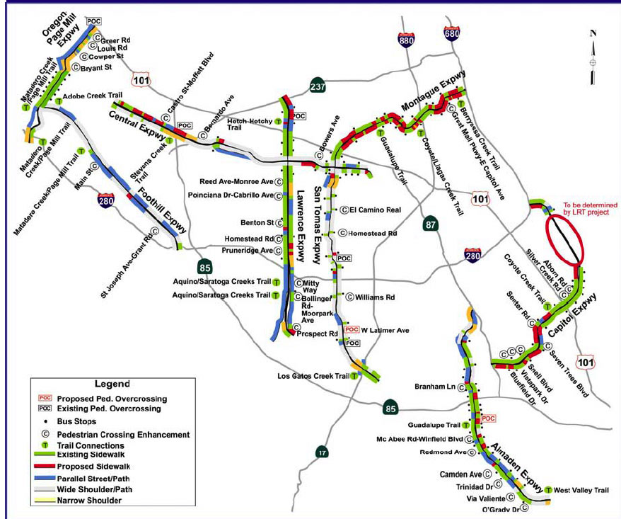
A deficiency of all the 2003 maps is that where there are two traits along an expressway (as described in the legend), it would only show one trait on each side of the road, instead of showing two colors of the two traits. For example, where there are existing wide shoulders (grey) AND future planned sidewalks (red), only color red is shown. Another example: Foothill Expressway has shoulders uniformly 8 feet wide (grey), but where there is a parallel road, (blue), it would show only blue, not both grey and blue. The apparent logic, that walkers would use the parallel road, is not entirely valid because many parallel roads have no shoulders or sidewalks, and using the expressway shoulder would be safer than walking in the traffic lane of the parallel road.
Note: This important portion from 2003 was completely eliminated in the 2008 update by County highway staff, who have fought against bicyclists and pedestrians use of shoulder and path for years.
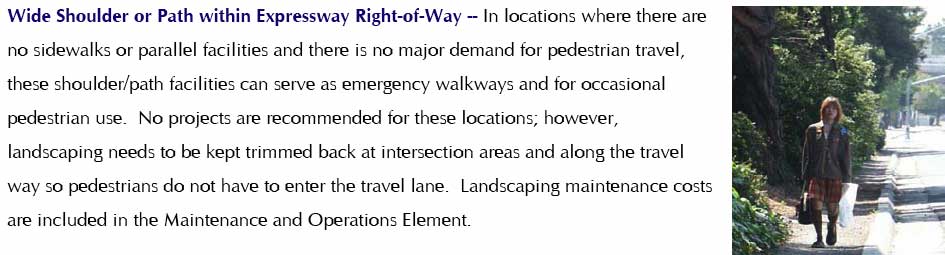
Page 93 (excerpt paragraph with photo, below) of the 2003 County Expressway Plan (main section) has two important quotes:
"shoulder or path facilities can serve ... for occasional pedestrian use." and
"landscaping needs to be kept trimmed back at intersection areas and
along the travel way so pedestrians do not have to enter the travel lane.".
Each expressway also its own section, with a separate pdf file, and includes a pedestrian-expressway map of that expressway.
These can be downloaded from the websites of the County or MTS (Modern Transit Society).
To save several clicking steps,
MTS has copied to its website four of these documents. [Censorship 2024 update: Contact Akos Szoboszlay for others, the transmittal document, etc.]:
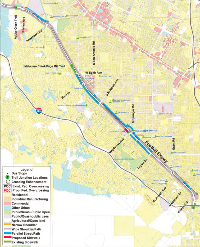
[San Tomas] [Foothill]
[Montague] [Lawrence]
and exerpted two of these maps: [San Tomas] [Foothill].
Note regarding Lawrence map: Many shoulders of Lawrence were widened since 2003, so the map needs updating to show these shoulders as "wide".
Or, download from the County's website: www.expressways.info
Many of the same features that make the road safe for bicyclists apply also to pedestrians. The separate bicycle section can be downloaded from the County's web site (then click "County Bicycle Guidelines"). Censorship 2024 update: This document was also censored by County Roads, so download it from Modern Transit Society website .
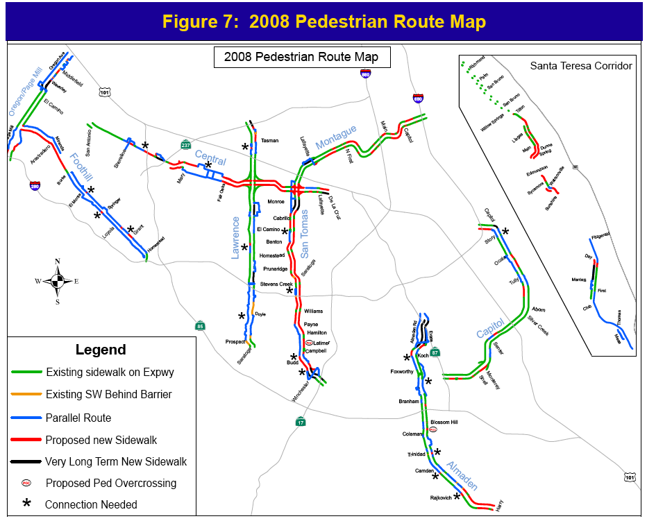
Maps and the Plan can be downloaded [changed link] County's expressway website. For convenience, the main (all-expressway)
pedestrian map is below. The most dramatic change of 2008, compared with the 2003 map, is that sidewalks are shown along San Tomas. County staff actually fought against
sidewalks along San Tomas from 2005 until the 2008 draft, which was approved on 3/3/2009.
The 2008 plan contains routes (on expressway-specific pedestrian maps) and guide signs - also called directional signage - where a closely parallel route exists. However, nothing has been done, as of 2024, to create and post such signs.
The 2003 Plan also mentioned guide signs but, again, nothing was done. Guide signs are mentioned in the expressway-specific document sections.
Here is an example quote from the San Tomas section, page 8:
"Recommendations also include improved connections and directional signage to parallel pedestrian facilities, such as trails."
[See examples of Guide signs and details.]
The VTA/County Bicycle-Pedestrian Advisory Committee [VTA BPAC] and MTS had significant input into the 2003 County Expressway Plan.
The original draft of the 2003 County Expressway Plan (then called "Expressway Study") stated that pedestrians would be prohibited unless there is a sidewalk. This meant that pedestrian paths, shoulders and bike lanes would be newly prohibited to pedestrians, even where they have always been allowed, and with total disregard for their right to use roadways under State law. County Roads also contradicted the BOS path creation order of 1991, which the BOS fully funded, and was supposed to be completed by 1995. County Roads was using their non-compliance in their attempt to eliminate pedestrians and transit patrons.
The final version, which was endorsed by most cities [see the transmittal] and approved by the Board of Supervisors (BOS), rejected that, as shown above. (The 1991 Board order to create pedestrian paths along expressways was not changed.) While the final 2003 County Expressway Plan did not address all of the topics MTS requested, such as hierarchical street pattern, it does draw the correct conclusions. Here are MTS actions that helped bring this about:
MTS wrote to the VTA BPAC:
MTS wrote to the Expressway Study Manager:
MTS also spoke to the Study's PAB and met with staff.
Then, MTS had to go through the same fight all over again, from 2005 until the the draft Update to the Expressway Plan in 2008 (which added sidewalks). County Roads went to all the cities to oppose sidewalks along expressways. I went to all the cities to rebut them. County Roads lost the votes. Sidewalks were approved by the Board of Supervisors on 3/3/2009. Highway staff tried to take advantage of the secret change in State law that they wrote which enabled this to occur, even after the BOS voted to seek repeal in January 2006, by a 5-0 vote.
The conclusion is that, as for the 2003 Plan, there are no pedestrian (or bicycle) prohibitions in the 2008 County Expressway Plan, and pedestrian (and bicycle) facilities are required.
I had forgotten I wrote this article, and re-discovererd it when updating this website to include the 2024 censorship of County Roads. Notice the second to last paragraph where I stated that County Roads "inserted the prohibition of pedestrians and bicycles into the [T2010] Plan". After writing this article, the BOS told County Roads to meet with me, and the BOS approved the 1991 polices.
County Roads failed to eliminate pedestrians for the T2010 Plan and for the 2003 Expressway Plan, and to eliminate sidewalks for the 2008 Plan. What will they try next?