A study in 2003, "Safety in numbers: more pedestrians and bicyclists, safer walking and bicycling" by P. L. Jacobsen
[http://ip.bmjjournals.com/cgi/content/full/9/3/205]
has this conclusion:
The more drivers expect pedestrians or bicyclists, typically as the number of pedestrians or bicyclists increase, the
lower the risk of colliding into them, per walker or bicyclist. The "pedstrians prohibited" signs increase risk by decreasing pedestrians.
Typically, the pedestrian count triples after signs banning them are removed (an observation by Akos Szoboszlay).
From the study's conclusion, this fact alone doubles the safety of pedestrians.
But another factor also comes into play which probably has greater effect, described next.
The study concludes that "It appears that motorists adjust their behavior in the presence of people walking and bicycling."
Because motorists are misinformed by a sign stating pedestrians prohibited that pedestrians do not exist on the roadway, then the signs
increase the accident rate because drivers won't expect pedestrians. This is a corollary, or a logical deduction from the study's conclusions.
Pedestrians prohibited signs do not stop all pedestrians due to lack of nearby
alternatives or they don't understand the signs.
There is a power of 0.4 fatality increase for the road as the pedestrians/bicyclists increase --less than a square root
(which is power of 0.5).
Per walker/bicyclist, there's a great risk reduction. It is power of -0.6, which is the same as power of 0.4 and then
dividing by the increase (division is same as multiplying by power of -1), giving power of 0.4 - 1 = -0.6
For example, if 9 times more people walk/bicycle, the collision rate increases by 2.4 for the road, but decreases per
walker/bicyclist by 2.4/9, or about one-fourth the risk for each person.
For more info or questions, contact Akos Szoboszlay, President, Modern Transit Society.
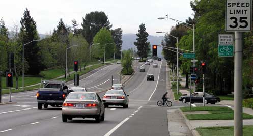
Photo: Page Mill Road in Palo Alto, 35 mph, is an official County expressway.
The word Expressway in the road name misleads many car drivers not to watch out for pedestrians and bicyclists. Most at risk are slow pedestrians and slow bicyclists crossing the Expressway who don't make it all the way across before the signal changes. Drivers don't expect them to be there because in most other states, an expressway is a freeway --except for often not being "free" due to a toll (or "road fare"). It is a mistake to have drivers --usually out-of-towners or new residents-- think that the Expressway is a freeway.
The misleading name also becomes an attitude problem for a few drivers who
think bicycles and pedestrians don't belong on expressways, which they associate with freeways. They make their attitude
known when passing them --sometimes by inches with their horn blaring.
All Expressway names should either be changed back to what they were before -- Avenue or Road --
or changed to an efficiently short name, such as Way.
Some politicians also succumb to this fallacy. County Supervisor Gage said, "I consider them freeways -- they are freeways." [at the
HLUET February 2004 meeting]. He also stated he wants bicycles banned from Mount Hamilton Road [at the May 4, 2004
Board meeting].
The attitude problem is also reflected in the County Roads and Airports Department. Mr. Murdter, Director,
told the County Supervisors [at the
HLUET February 2004 meeting and
in his staff report] that expressways are freeways and that he can ban pedestrians [and logically,
bicycles] at will -- his. This was subsequently
retracted to the Board of Supervisors [May 4, 2004] after several MTS letters to the County Executive and County
Counsel. The Board then ordered Murdter to remove pedestrians prohibited signs in Sunnyvale and anywhere else they were illegal. [May 4, 2004]
The links in this table are to MTS' advocacy pages or to historical web pages. The suggested name change is to improve safety.
|
Name today |
Suggested name |
History and notes |
|---|---|---|
|
Page Mill Road |
(no change) |
Page Mill Road is an official county expressway, and proves that expressway roads don't need to end with the word Expressway. |
|
Oregon Expressway |
Oregon Avenue |
Oregon Expressway is 35 mph. Calling it Expressway is wishful thinking on the part of highway engineers and 1960s auto-centric politicians. This pretense is risky for non-motorists. This road is a continuation of Page Mill Road. It was formerly Oregon Avenue, a two-lane street. |
|
Peninsular Way |
Peninsular Avenue and the Southern Pacific passenger train service from Los Gatos to Palo Alto was eliminated for Foothill Expressway when, in 1964, train service was stopped and the tracks were destroyed to build it. Land for an adjacent track, used from 1905 to 1934 by the electric interurban trains of the Peninsular Railway from Palo Alto to San Jose, was also taken. |
|
|
Lawrence Expressway |
Lawrence Way |
Lawrence Station Road was the former name. Lawrence train station was used until 1945. In 1982, it re-opened under Caltrain. |
|
Montague Road |
Montague Expressway was formed from three pre-existing roads: Montague Road (western portion), Trimble Road (central portion in line with Trimble Road today), and Landess Avenue (eastern portion, which continues today). It is interesting to note that Trimble Road had a 50 mph speed limit (changed to 45 in May 2007), greater than Montague at 45 mph. |
|
|
Capitol Avenue |
Formerly was named Capitol Avenue, which still continues from it. Two months after adding lanes and constructing a shoulder that was 10 feet wide -- without even changing the speed limit of 45 mph -- the County highway engineers posted pedestrians bicycles ... prohibited signs. After 15 years, these signs were changed to bike lane, finally allowing bicyclists to use the bike lane. The Capitol LRT Station is directly above the Expressway. |
|
|
Almaden Expressway |
Almaden Way |
Formerly named Almaden Road, a portion of the old road parallels it today so a different name ending is needed. |
|
San Tomas Road |
San Tomas is the only expressway that was a mostly new road, mostly built along or on top of San Tomas Aquino Creek. However, the southern portion was Camden Avenue, which is its continuation today, the portion near El Camino was Los Olivos Drive, and the portion north of Central Expressway (which then was named Kifer Road) was Montague Road. |
|
|
Central Expressway |
Central Road |
Central Expressway was formed from three pre-existing roads: Alma Street (between the continuation of Alma today and Orchard Ave. near Hwy 85), Argues Avenue (between Mathilda and today's Arques) and Kifer Road (between todays's Kifer Road near Bowers Ave. and De la Cruz Blvd.). |
|
Southwest Expressway |
Southwest Road |
This 40 mph arterial road, previously 45 mph until many driveways were added, is not part of the County Expressway System, but rather, the City of San Jose. |
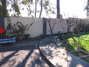
Photo at right: Los Olivos Drive [map from 1950s] is behind the sound wall, and is now named San Tomas Expressways. This sound wall (and the predecessor fence) severed north-south travel to bicyclists and pedestrians. Pedestrians Bicycles ... Prohibited signs were posted. Los Olivos was renamed San Tomas Expressway, a 45 mph arterial road that should also have accommodated non-motorists. Today, the other side of the wall is a shared-use path. Clearly, an opening in the wall is needed for bicyclists and pedestrians to enable use of this path, rather than force them into a significant detour to reach El Camino, a major shopping street and transit line, that is just one block away. More photos in Santa Clara (City) pictorial report.
1) Posting pedestrians prohibited signs increases danger. These should be removed because they:
Removing "pedestrians prohibited" signs increases safety by minimizing crossings of all types: commercial driveway, street, and arterial (including the expressway).
2) Renaming all expressways back to Avenue or Road, or to select a different name such as Way, upon agreement with the cities that contain the expressway, would eliminate the misconception among some motorists (especially those from out-of-town or new residents) that non-motorists don't exist on expressways.